Home » Hunting Gear » OnX Hunt – Practical Application in Bird Hunting
OnX Hunt – Practical Application in Bird Hunting

Nick Larson is the host and creator of the Project…
How to use OnX Hunt to replace Plat Books as the ultimate bird hunting app.
When it comes to hunting—and hunting upland birds—there’s almost no such thing as having too many tools in your arsenal. One tool that is becoming ever more important is a smart phone and a bird hunting app. Used correctly, they can provide access to a wealth of knowledge at your fingertips.

Having accurate and immediate information when you’re in the field is crucial. Having the right apps on your phone can help provide that information.
Continuing with my killer bird hunting app series, I want to highlight another app that has become indispensable to my upland bird hunting adventures. Admittedly, there is some overlap between this one and one I previously highlighted, Google Maps, but its main functionality is what truly sets it apart. The name? onX Hunt.
Like Google Maps, onX Hunt provides you with a virtual map. All of my upland hunting is dependent on the ability to navigate, find, and scout for public-access land. The more land you have access to the better your chances of staying in productive cover. It doesn’t matter if you know everything there is to know about upland bird habitat. If you don’t know where to find it and where to access it, what good is that information?
In order to hunt upland birds, first, you must find cover to hunt. That’s not all—finding accessible land is one thing, getting to know the cover is another. The landscape, including upland bird habitat, is always changing due to various influences and disturbances over time. As a bird hunter, you must be ever-vigilant when it comes to searching for new, productive grounds. Doing it the old way, with boots and tires, remains an option, and a key piece of the puzzle. Scouting beforehand is another piece in my upland bird hunting puzzle. Utilizing technology and the ability to scout bird cover virtually has enabled me to significantly increase my productivity and use of time in the field.
Back in the days before smartphones, the county plat book was the holy grail to many an upland bird hunter. They were one of the few relatively convenient ways to look up whether a parcel of land was owned privately or open for public hunting. Again, knowing what you do and do not have access to is one of the main keys to upland hunting success. As my good friend Ted Dick, the Minnesota DNR Forest Gamebird Coordinator, likes to say, “Grouse hunting is a public land sport.”
Fortunately when it comes to land access information, some things have changed for the better. County plat books, though they contain essential information, they also have their drawbacks which kept me from using them for most of my hunting career. I am fortunate to have never ticked off any landowners enough to get myself into real trouble, but I had my fair share of uncomfortable situations and I’d prefer to avoid that kind of thing in the future.
What are those drawbacks? Most of the time, at least in my neck of the woods, a county plat book is just that, land information for a single county, which means you’re going to need one for every county you plan to hunt. If you want to be well prepared that is, and most of the upland hunters I know hunt more than one county, especially over the course of a season! The point is, if you’re spending the thirty dollars or more per book for each county you want to hunt, the cost of doing business adds up quickly. This isn’t the only issue. As time goes on, county plat books become outdated. Land ownership changes, properties move in and out of public access, and most counties cannot justify updating their plat books every year. If you go this route, you’ll be constantly updating and recycling your library of plat books. If that doesn’t interest you, let me tell you about a better way.
Listen: Upland Hunting with onX Hunt and Ben Brettingen – Project Upland Podcast #120
Replacing the Plat Book Once and For All
I started using onX Hunt last year and was amazed at the quantity and quality of information it provided me, to say nothing of its easy and responsive interface. Aside from a host of additional features and benefits, onX Hunt is essentially a plat book for the entire country, that’s right every state. Forget about counties—when you purchase onX Hunt, you gain access to land ownership information across whole states making it the most effective bird hunting app with respect to land access information. For most upland hunters, one or two states will likely be sufficient. Last year, however, I hunted upland birds in four different states, so I purchased their Elite membership. It gave me access to all fifty states!
For the price of a single county plat book, you gain access to an entire state. Not only that, but the team at onX Hunt ensures that you are hunting with the latest, most up-to-date information. The subscription lasts a full year. When you start to consider the cost of upgrading your plat books for each county you want to hunt, there’s really no comparison to be made. The onX Hunt bird hunting app wins every time.
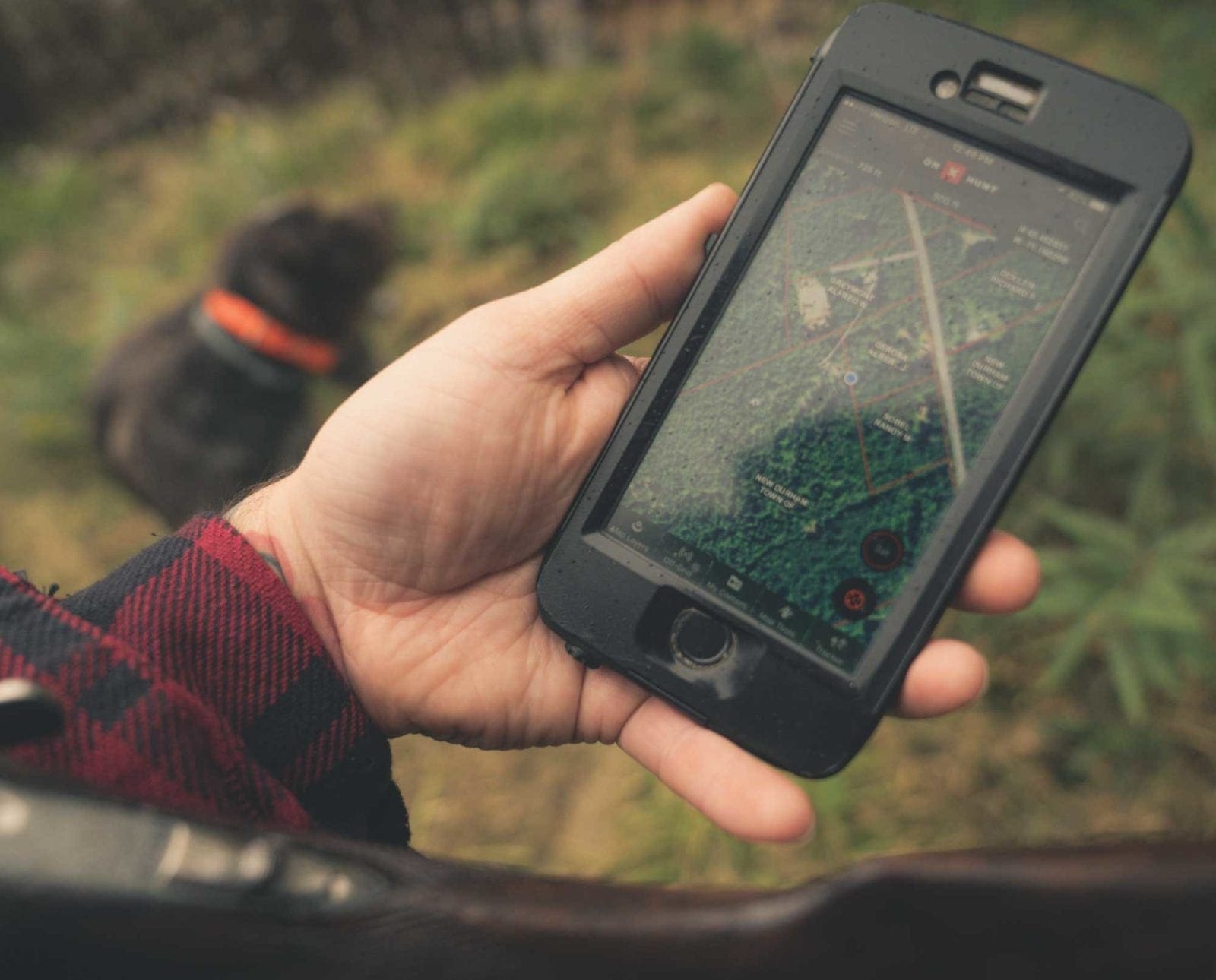
Price isn’t the only win for onX Hunt. Instead of paging through a book of maps, the onX Hunt interface is digital and interactive. Like other digital mapping platforms, you can swipe around and zoom in and out of areas, while onX Hunt overlays the land information right on top of the map, be it basic, topographical, or satellite imagery.
The Best Bird Hunting Apps for Land Access Information
Imagine how useful this could be on your next outing. You’re driving along a forest road and spot a piece of potential bird cover. You pull up onX Hunt and instantly load the land ownership information all around your location and know immediately whether or not you have access. As you move through the field onX Hunt tracks your location in real time so you can view your position relative to physical and legal boundaries. It has never been easier to check and monitor land access while in the field. Even without cell service, onX Hunt has you covered. There is an offline map feature that allows you to download the information about an area right to your phone. This feature is a must as the areas we hunt are often times, off the grid.
onX Hunt has a whole host of other features: GPS tracking, breadcrumbs, waypoint logging, and more. I also use the track log to monitor my time in the field as well as distance covered as I keep rather detailed statistics on my bird hunting. On top of all that, the onX Hunt app recently received a makeover that improved the looks and functionality dramatically.
If you’re looking for the latest and greatest in hunt mapping technology, I would strongly recommend you give this bird hunting app a shot this season. For less than the price of most county plat books, you’ll have access to the information you need and much more. Few tools have upland bird hunters covered like onX Hunt.
COST: $29.99 by State (per year). $120.00 all 50 States (per year). *Note these prices reflect the cost at the time this article was published and could vary overtime and promotions.
Nick Larson is the host and creator of the Project Upland Podcast. He and his family, which includes a pair of English setters, reside in Duluth, Minnesota. Naturally, his favorite pursuit is upland bird hunting. From the northern forests of the upper great lakes to the prairies of the west, he chases adventure across the uplands wherever his bird dogs and the people he meets inspire him to go.


Great article. I use onX just about every day. Even when I’m not hunting. If I’m playing on my phone on my lunch break, chances are I’m scouting!
Thanks Andrew! Right there with you, especially this time of year… so many possibilities!
You should footnote the claim “Not only that, but the team at onX Hunt ensures that you are hunting with the latest, most up-to-date information.” I have he app and the chip and I can tell you hat landowner data in Colorado is over two years out of date. I contacted them and their reply was “It’s the latest data *from our GIS provider*.” So it’s not the most up to date information, after all. While it’s a handy app for sure, always double check with authoritative sources.
We make an effort to update each state at least once per year, using data compiled from each county. Some counties and townships are better at keeping their records up-to-date than others. If you provide us with the locations of properties you know have changed hands along with the names of the new owners, we’ll verify this information with the county data the next time we update your area. Check out this link for a map of our current coverage for each state! https://www.onxmaps.com/parcel-coverage
How does onX do in areas with limited or no cell coverage?
never mind didn’t finish the article before posting
So what is the cost? I can’t figure out what’s what on their site. Is it $120 a state and what do the premium or elite subscriptions give me. Is that per year? There is now real explanation on their site…just click here to purchase.
Cost is a factor don’t you think? A “good” article would include that IMO. How about explaining what you get, for how long, and how much it all costs…in plain English.
Hey Gary! Just browsed through their site and see what you are talking about. We are updating the article now to reflect the cost by state, and by all 50 states. Per state is $29.99 (per year) and the 50 states is the $120 (per year). Thanks for the input!
I am new to upland hunting and was wondering how does one “e-scout?” How do you know what tree is an aspen vs pine? Things to look for. Elevations and so on. Some tips on how to use onx to find birds not just parcels would be great. Thanks